Eilean Donan, Scotland
A castle on a tidal island where three sea lochs meet.
Terra Explorer Castles and hilltop monasteries
Drag to rotate · scroll or pinch to zoom
Make this model
The Standard resolution model is free as STL, 3MF, Colored 3MF, OBJ and a 16-bit heightmap. High resolution samples the place about ten times more finely.
- Region
- Scotland
- Position
- 57.2742, -5.5160
- Area
- 5 × 5 km
- Real elevation
- 0 to 513 m (513 m of relief)
- Printed size
- 150 mm (5.9 in) wide, about 1:33,300
- Heights
- 1.5× exaggeration
- Elevation data
- Open satellite data (SRTM and others), about 30 m per point
- Suggested color
- Natural
- Group
- Castles and hilltop monasteries
About Eilean Donan, Scotland
Eilean Donan (Scottish Gaelic: Eilean Donnain) is a small tidal island situated at the confluence of three sea lochs (Loch Duich, Loch Long and Loch Alsh) in the western Highlands of Scotland, about one kilometre (5⁄8 mi) from the village of Dornie. It is connected to the mainland by a footbridge that was installed early in the 20th century and is dominated by a picturesque castle that frequently appears in photographs, film and television. The island's original castle was built in the thirteenth century; it became a stronghold of the Clan Mackenzie and their allies, the Clan MacRae. In response to the Mackenzies' involvement in the Jacobite rebellions against the newly United Kingdom, Royal Naval ships destroyed the castle in 1719. The present-day castle is Lieutenant-Colonel John Macrae-Gilstrap's 20th-century reconstruction of the old castle.
From Wikipedia: Eilean Donan, text available under the Creative Commons Attribution-ShareAlike 4.0 license. The article’s history lists its authors.
Questions about Eilean Donan, Scotland
Where is Eilean Donan?
Eilean Donan is in Scotland at 57.2742, -5.5160. The model covers a 5 by 5 kilometer square around that point.
How high is the terrain in the Eilean Donan model?
The land in this model runs from 0 to 513 m (513 m of relief). These are the measured heights, printed 1.5 times taller so the shape is easy to see.
Can I 3D print Eilean Donan?
Yes. Download the free Standard resolution STL and print it on any FDM or resin printer. It is 150 mm wide and about 28.1 mm tall, on a solid 5 mm base, at a scale of about 1:33,300. It also works for CNC carving. Use Customize to change the width, base thickness or height exaggeration, make it round or add a name plate.
How accurate is the Eilean Donan model?
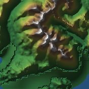
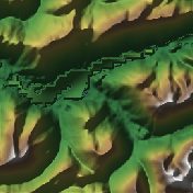
It is built from real elevation measurements, not an artist's guess: open satellite and survey data (NASA SRTM, Copernicus and national surveys), about 30 meters per point. The shaded picture on this page is made from the same data.
Is the Eilean Donan model free?
The Standard resolution model is free as STL, 3MF, Colored 3MF, OBJ and a 16-bit heightmap. High resolution samples the place about ten times more finely and is a paid upgrade.
What is a Eilean Donan terrain model good for?
People use it as a gift, a desk piece, or the base for a tabletop game or diorama.
About this terrain model
Embossify Terra builds Eilean Donan, Scotland from real measured elevation, not an artist's guess. Outside the United States the heights come from open satellite and survey data (NASA SRTM, Copernicus and national surveys), about 30 meters per point.
The model covers a 5 by 5 kilometer square centered on 57.2742, -5.5160. It prints 150 mm (5.9 in) wide on a solid base, a scale of about 1:33,300. The heights are exaggerated 1.5× so the shape is easy to see and feel; you can change that when you customize the model. The sea is flattened to zero, so land stands on a clean base.
New to terrain printing? Read how Terra works. The shaded picture on this page is made by Embossify from the same elevation data.